

 登录
登录
C
KEY→P37
范畴:人与社会 主题:技术创新 体裁:说明文 难度:★★★★ 建议用时:6分钟 评价:/5
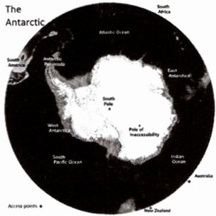
A team of scientists has made a map of Antarctica. The map shows thousands of hills, mountains and low places under the ice that no one has ever seen before. This new information can help scientists know how climate change will harm this icy continent.
Antarctica is almost one and a half times as big as Europe. Most of the continent is covered
英语嗨吧
with ice. In some places, the ice is three miles thick. This thick ice makes it hard to see what the land under it looks like. The new map has solved this problem.
To make the new map, the scientists used satellite pictures, studies of the ice surface and knowledge of how ice moves. Ice acts differently from water. But the scientists still found out how the ice flows. They also found the exact places of the mountains and valleys under the ice. Helen Ockenden is the lead scientist of the study. She said, "It's a little like boating in a river with rocks under the water. Sometimes there are eddies that can tell you where the rocks under the water are."
It is important to make a clear map of the land under Antarctica. The Earth is getting warmer, so Antarctica is losing ice. When the ice melts, it flows into the ocean. This makes sea level rise. Scientists are not sure how much ice Antarctica will lose in the future. They also don't know how much sea level will rise because of this melting ice. The shape of the land influences how fast the ice moves on it. And the speed of the ice movement influences how fast sea level rises.
Experts say the new map will help people understand what will happen in the future. Ockenden told BBC News, "It's like before you had a common camera that took low-quality pictures. Now you have a clear digital camera that can look closer and show you exactly what is happening."
——文章选自 News for Kids
(
A. Important.
B. Common.
C. Famous.
D. Traditional.
(
A. Ice stops all satellite signals.
B. Ice reflects too much sunlight.
C. Thick ice hides the land surface.
D. Land shapes change too quickly.
(
A. By taking in heat from the air.
B. By controlling the speed of the ice movement.
C. By changing ocean water directions.
D. By stopping wind across the continent.
(
A. Digital cameras help make better maps.
B. The old map was as clear as the new one.
C. The new map provides clearer information.
D. Scientists need better cameras to study ice.
(
A. To ask people to protect Antarctica.
B. To tell people about Antarctica's size.
C. To teach scientists how to make maps.
D. To introduce a new map of Antarctica.
D
KEY→P38
KEY→P37
范畴:人与社会 主题:技术创新 体裁:说明文 难度:★★★★ 建议用时:6分钟 评价:/5
A team of scientists has made a map of Antarctica. The map shows thousands of hills, mountains and low places under the ice that no one has ever seen before. This new information can help scientists know how climate change will harm this icy continent.
Antarctica is almost one and a half times as big as Europe. Most of the continent is covered
英语嗨吧
with ice. In some places, the ice is three miles thick. This thick ice makes it hard to see what the land under it looks like. The new map has solved this problem.
To make the new map, the scientists used satellite pictures, studies of the ice surface and knowledge of how ice moves. Ice acts differently from water. But the scientists still found out how the ice flows. They also found the exact places of the mountains and valleys under the ice. Helen Ockenden is the lead scientist of the study. She said, "It's a little like boating in a river with rocks under the water. Sometimes there are eddies that can tell you where the rocks under the water are."
It is important to make a clear map of the land under Antarctica. The Earth is getting warmer, so Antarctica is losing ice. When the ice melts, it flows into the ocean. This makes sea level rise. Scientists are not sure how much ice Antarctica will lose in the future. They also don't know how much sea level will rise because of this melting ice. The shape of the land influences how fast the ice moves on it. And the speed of the ice movement influences how fast sea level rises.
Experts say the new map will help people understand what will happen in the future. Ockenden told BBC News, "It's like before you had a common camera that took low-quality pictures. Now you have a clear digital camera that can look closer and show you exactly what is happening."
——文章选自 News for Kids
(
A
)1. Which is the best word to describe the map?A. Important.
B. Common.
C. Famous.
D. Traditional.
(
C
)2. Why is it hard to see the land under the Antarctic ice?A. Ice stops all satellite signals.
B. Ice reflects too much sunlight.
C. Thick ice hides the land surface.
D. Land shapes change too quickly.
(
B
)3. How does the land shape influence the rise of sea level?A. By taking in heat from the air.
B. By controlling the speed of the ice movement.
C. By changing ocean water directions.
D. By stopping wind across the continent.
(
C
)4. What can we guess about Ockenden's opinion?A. Digital cameras help make better maps.
B. The old map was as clear as the new one.
C. The new map provides clearer information.
D. Scientists need better cameras to study ice.
(
D
)5. What is the writer's purpose in writing the passage?A. To ask people to protect Antarctica.
B. To tell people about Antarctica's size.
C. To teach scientists how to make maps.
D. To introduce a new map of Antarctica.
D
KEY→P38
答案
科学家绘制出南极洲冰下地形新地图,借助多种技术探明冰下地貌。该地图对研究冰层变化、海平面上升及气候变化影响至关重要,能帮助人类更好地预知未来。
1. A 推理判断题。由第一段中“This new information can help scientists know how climate change will harm this icy continent.”可知,用important一词描述a map of Antarctica。
2. C 推理判断题。由第二段中“This thick ice makes it hard to see what the land under it looks like.”可知,难以观测南极冰层下的陆地是因为厚冰覆盖冰层下的地表。
3. B 推理判断题。由第四段中“The shape of the land influences how fast the ice moves on it. And the speed of the ice movement influences how fast sea level rises.”可知,通过控制冰的运动速度来影响海平面上升。
4. C 推理判断题。由“It's like before you had a common camera that took low-quality pictures. Now you have a clear digital camera that can look closer ...”可知,奥肯登用相机作比喻,说明以前的地图(普通相机)信息模糊,新地图(高清数码相机)信息更清晰。
5. D 推理判断题。本文作者介绍南极洲冰层下新地图的制作、内容、重要性,目的是向读者介绍这张新地图。
1. A 推理判断题。由第一段中“This new information can help scientists know how climate change will harm this icy continent.”可知,用important一词描述a map of Antarctica。
2. C 推理判断题。由第二段中“This thick ice makes it hard to see what the land under it looks like.”可知,难以观测南极冰层下的陆地是因为厚冰覆盖冰层下的地表。
3. B 推理判断题。由第四段中“The shape of the land influences how fast the ice moves on it. And the speed of the ice movement influences how fast sea level rises.”可知,通过控制冰的运动速度来影响海平面上升。
4. C 推理判断题。由“It's like before you had a common camera that took low-quality pictures. Now you have a clear digital camera that can look closer ...”可知,奥肯登用相机作比喻,说明以前的地图(普通相机)信息模糊,新地图(高清数码相机)信息更清晰。
5. D 推理判断题。本文作者介绍南极洲冰层下新地图的制作、内容、重要性,目的是向读者介绍这张新地图。
